Ptolemy

Around Britain with a theodolite: a celebration of the Ordnance Survey maps

It took six years, starting in the summer of 1784, for the Board of Ordnance to establish the baseline of its triangulation of Great Britain. First they used wooden poles, then glass tubes. After much clearing of furze bushes and ant hills, the baseline ran for more than five miles from Hounslow Heath to Hampton Poor House. The maps of England and Wales were complete by 1870. Scotland had to wait until 1887. The delay was rumoured to have been caused by the superintendent’s concern that surveyors would get in the way of the late summer deer stalking. As a wing of the military, the Ordnance Survey had extraordinary powers. The Surveyors’ Act of 1841 allowed it to trudge, clamber, squelch, measure and interrogate wherever necessary.

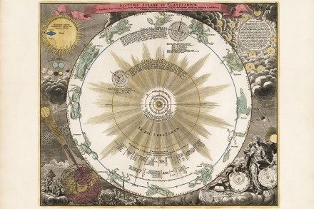
Heavenly beauty: Doppelmayr’s Atlas Coelestis

It seems something of a disservice to a work of this seriousness to say how beautiful it is, but that is what will first strike the reader. Open this book and if you can prise yourself away from its wonderful marbled end papers, with their swirls and drifts of deepest blue, brilliant flashes of rusty orange, rivulets of ochre, inky spheres and floating masses of fiery red, you will find yourself taken back to the Enlightenment world of Johann Gabriel Doppelmayr’s Celestial Atlas and an age in which Europe’s polymaths were as interested in the discoveries of science as they were in the literary and artistic culture of the day. The Atlas Coelestis, published in 1742, is an extraordinary work consisting of 30 plates illustrating everything that was known of the cosmos at the time.